
Engineering-geological surveys for construction
Engineering-geological surveys and laboratory soil testing.
Engineering geological surveys represent an indispensable set of field, laboratory, and analytical investigations designed to comprehensively evaluate subsurface soil stratigraphy, physical-mechanical ground parameters, and groundwater conditions across a planned construction site.
A set of engineering-geological works at the construction site to obtain soil data required for the design of foundations and bases.
In Tashkent and across all industrial regions of Uzbekistan, the licensed engineering center GEO PRO delivers certified engineering geological surveys Tashkent in full compliance with national urban planning codes and KMK / ShNK engineering standards.
Conducting comprehensive engineering geological surveys ensures the long-term structural integrity of future facilities. High-precision geotechnical investigations for construction Uzbekistan allow structural engineers to accurately calculate ground bearing capacity, predict settlement behavior, and prevent differential structural cracking.
A timely foundation geotechnical survey Tashkent optimizes zero-cycle construction expenditures, eliminating unnecessary over-dimensioning of raft foundations, pile groups, or retaining wall systems.
When Engineering Geological Surveys are Required for Construction
In compliance with the Urban Planning Code of the Republic of Uzbekistan, comprehensive engineering geological surveys are mandatory for:
- Multi-storey residential developments, high-rise office towers, and commercial complexes;
- Industrial plants, heavy manufacturing facilities, logistics parks, and warehouse hubs;
- Linear infrastructure projects: transport highways, railway corridors, bridge crossings, and utility pipelines;
- Reconstruction, structural underpinning, and vertical expansion of existing facilities;
- Assessing geological hazards such as landslides, karst voids, suffosion, and collapsible soils.
Field Exploration: Geotechnical Drilling and In-Situ Penetration Tests
The fieldwork conducted by GEO PRO begins with visual site reconnaissance, geodetic pegging of borehole coordinates, and setting up the exploration grid.
Our specialized drilling fleet performs advanced geotechnical drilling and core sampling Tashkent with continuous retrieval of undisturbed soil core samples (monoliths) to targeted design depths.
To evaluate soil density and load-bearing resistance in undisturbed natural conditions, we utilize standard cone penetration testing CPT Tashkent, dynamic probing, and in-situ borehole plate load testing. Professional engineering geological surveys rely on precise calibration of all testing equipment.
During borehole drilling, geotechnical specialists determine stabilized groundwater levels, record ingress rates, and collect water samples for laboratory corrosivity evaluation.
Laboratory Assays: Soil and Rock Mechanics Laboratory Testing Uzbekistan
Undisturbed soil monoliths and groundwater samples are delivered directly to our ISO-accredited geotechnical testing laboratory.
Under international ASTM, ISO, and national GOST standards, we perform comprehensive soil and rock mechanics laboratory testing Uzbekistan:
- Particle size distribution analysis (granulometry) and soil classification (sands, silts, loams, clays, and loess);
- Physical index properties: moisture content, dry density, specific gravity, porosity, void ratio, and Atterberg limits;
- Mechanical properties: angle of internal friction, cohesion, and modulus of deformation via triaxial and direct shear tests;
- Collapse potential and initial settlement pressure testing for moisture-sensitive loess soils;
- Expansive soil swell-shrink potential, frost heave susceptibility, and piping suffosion resistance;
- Chemical analysis of soil water extracts to detect chemical aggressiveness against concrete and steel reinforcement.
Cameral Analysis and Geotechnical Report for State Expertise Uzbekistan
Upon concluding field explorations and laboratory testing, our geotechnical engineers perform numerical analytical calculations and computer-aided foundation modeling.
The outcome of our work is an official geotechnical report for state expertise Uzbekistan, fully prepared to pass regulatory scrutiny:
- Comprehensive explanatory note with regional geomorphological, seismological, and climatic characteristics;
- Lithological borehole logs detailing individual geological layers and soil strata;
- Longitudinal and cross-sectional geological profiles plotted along structural building axes;
- Statistical summary tables of normative and calculated physical-mechanical values for each Engineering Geological Unit (EGU);
- Hydrogeological assessment reports regarding groundwater table regimes and seasonal high-water marks;
- Practical foundation design recommendations: optimal foundation depth, pile bearing capacity calculations, and moisture protection;
- Full compliance documentation guaranteed to obtain approval from the State Urban Planning Expertise Board.
Pricing Factors and Engineering Geology Services Cost Tashkent
When estimating your project budget, the engineering geology services cost Tashkent is determined by several core parameters:
- Geotechnical category and geological complexity of the development plot;
- Building footprint dimensions, total height, and structural importance category;
- Required number, depth, and spatial spacing of exploratory boreholes;
- Terrain accessibility and ground conditions for heavy truck-mounted drilling rigs;
- Scope of specialized in-situ static penetration and laboratory compression tests required.
GEO PRO offers transparent pricing with fixed contract rates and no unexpected expense overruns.
How to Order Geotechnical Site Investigation Uzbekistan with GEO PRO
With our own versatile fleet of URB drilling rigs, certified testing facilities, and a dedicated team of geologists with over 15 years of field experience, GEO PRO guarantees accuracy and speed. Relying on accredited engineering geological surveys safeguards your investment throughout construction and facility operation.
If you need to order geotechnical site investigation Uzbekistan or request preliminary consultations for projects in Tashkent and regional hubs, our engineers will formulate a customized investigation program and provide a commercial quotation within 1 working day.
Need this service? Leave a request — we’ll estimate the cost for your site. Request an estimate or call: +998 97 744-55-11.
Why choose us
Licenses and permits
We work officially: a laboratory and permits for engineering surveys.
Modern equipment
Modern total stations, GNSS receivers and drilling rigs.
Experienced engineers
Surveyors, geologists and ecologists with specialized education and on-site experience.
Official report
A technical report accepted by expert review bodies and design organizations.
How we work
Request and brief
We clarify the task, site and objectives, and agree on the brief and cost.
Field work
We go on-site: measurements, survey, drilling and sampling to standards.
Processing
Office data processing, calculations and analysis in specialized software.
Report
We prepare and deliver an official technical report with results and recommendations.
Our work: geology
Projects completed by GEO PRO in this field — total 17.
Pile testing (Pile Drive & Pull-Out), Samarkand 2 Solar 500 MW
Drilling works (2000 m), Fergana region
Geotechnical surveys, LNG peak-shaving facility (Syrdarya, Tashkent, Turakurgan)
Steel pile test (DVT), photovoltaic plant (Kashkadarya)
Topographic-geodetic and engineering-geological surveys, Andijan PV plant 400 MW
Geotechnical and geophysical works, «Bash and Jankeldy» (Bukhara region)
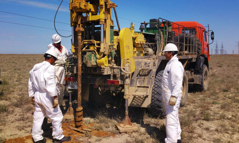
Topographic-geodetic and engineering-geological surveys, 500 MW WPP (Samarkand)
Engineering-geological survey of a power line (51 km), 500 MW solar plant (Sherabad)
Geotechnical studies, Nukus WPP (Karakalpakstan)
Cross-hole wave velocity measurements, 500 MW WPP (Bash, Zangeldy)
Engineering-geological surveys, 500 MW solar plant (Sherabad)
Engineering-geological surveys, combined power plant 1500–1700 MW (Uchkizil, Termez)
Geological exploration, «Dukhana» copper ore (Uzun district, Surkhandarya)
Engineering-geological surveys along a water-main route (65 km), Charvak — «New Tashkent»
Engineering-geological surveys (535 m drilling): Webster University and a school, «New Tashkent»
Engineering-geological surveys (635 m drilling): National Art Museum of Uzbekistan
Engineering-geological surveys (12 boreholes, 40 m each), «New Tashkent»
Thank you! Your request has been received
We will estimate the cost for your site and contact you shortly.